The Clyde River Retreat is 3.5 hours drive south of Sydney, or 2.5 hours drive east from Canberra.
The recommended route to the retreat from the north is via Milton. Go through the main part of Milton, then turn right off the highway at Croobyar Road (at the traffic lights), then follow it as it becomes Woodstock Road, and then Woodburn Road – in total for about 15km from Milton. You turn right off Woodburn Road on to Clyde Ridge Road at “Clyde Ridge Park”, where the tarmac ends. Clyde Ridge Road is signposted to Pigeon House and Yadboro. You follow the unsealed Clyde Ridge Road for another 14 km. About halfway along (7km) you will come to a big Y junction signposted again to Yadboro and Pigeon House to the right. You take the left fork. After another 7km Carisbrook Road will be on your left. It is signposted, but if you miss the turning you will reach the concrete ford crossing the Clyde River (known locally as the “upside down” bridge). Don’t cross it – Carisbrook Road is immediately BEFORE the ford. About 500m up Carisbrook Road you will see our sign.
If you are coming from the south (or west), the recommended route is to follow the Princes Hwy north from Bateman’s Bay. Turn off the highway at Monkey Mountain Road, which is on your left about 1km after you pass through Termeil (5km before Lake Tabourie). Follow Monkey Mountain Road for 5.5km until you get to the intersection with Brooman Road (signposted to Nelligen). Turn left onto Brooman Road and follow it for 8km until you you come to a T junction where Brooman Road takes a 90 degree left turn down the hill – you carry straight on across the top of the T onto Carisbrook Road and follow it for another 3.5km, until you see our sign and driveway.
If you are not comfortable on dirt roads (dry or wet), then you can also use the Monkey Mountain/Brooman Road route from the north – this route is gravel all the way to Carisbrook Road.
If you have a SatNav/GPS system, it may find our address (56 Carisbrook Fire Rd, Morton, NSW 2538). If not, many systems allow you to enter our geographic location in one of the following formats:
Decimal Degrees: -35.424698, 150.237292
Lat/Long: 35°25’28.9″S 150°14’17.3″E
Note: Your SatNav (and also Google maps) may offer you alternate routes. These are NOT recommended – they generally involve longer travel times and may require a 4WD. For instance, if you are coming from Sydney, you may be advised to turn off the highway at Termeil and then follow the Old Highway, Middle Ridge Road & Brooman Road to get to Carisbrook Road – however, this route involves more unsealed roads than the recommended route, and those roads are also used by State Forestry logging trucks. If you are coming from Canberra, you may be advised to turn off the Kings Highway at Lyons Road or The River Road – however, these routes are sometimes undrivable without a 4WD, and in any case take much longer than the recommended route.
Here is a map showing the recommended route to the retreat (click to see a larger version):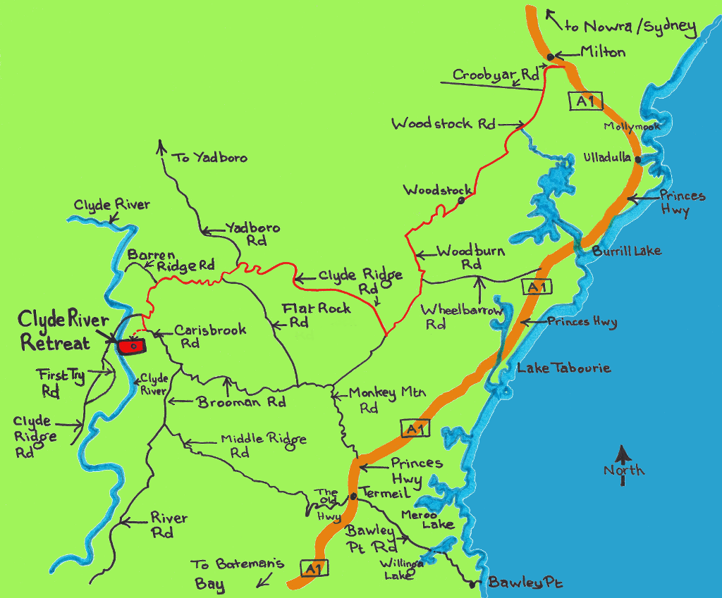
Or zoom in and out on the Google map applet below to see exactly where we are, or click on “View larger map” to view in Google Maps and get detailed directions from elsewhere: